
Community Engagement
MAS-GIS Support
GRS faculty and staff are very active in ASU's MAS-GIS program, including program administration, development of courses, and teaching in the program. In addition we work with ASU faculty and groups outside of ASU to help find opportunities for ASU students to expand their GIS skills while supporting the geospatial technical needs of the clients. Finally, we often take active roles advising for capstone projects. Some of the projects that GRS faculty have advised are below.
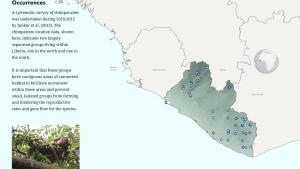
In this study, species distribution modeling (SDM) was used to identify areas of suitable habitat for the western chimpanzee species in Liberia. Suitable habitat was predicted by using 22 biophysical and social demographic predictor variables in addition to chimpanzee occurrence data. In 2015, the government of Liberia submitted its Intended Nationally Determined Contribution (INDC), stating their efforts for the protection of forest and biodiversity in rich forest zones and to increase the amount of forested land through reforestation of degraded lands (Republic of Liberia). This study is intended to contribute to the conservation efforts and protected areas for the country of Liberia.

Often referred to as ‘the nation’s silent mass disaster’ Missing Person and Unidentified Remains cases increase every year by the thousands. This project created a unified system that allows analysis on the spatial and data relationships of missing person and unidentified remains files using data provided by multiple departments with in Maricopa County, Arizona. The three-point system contains a secure investigation application, background data support and an outreach story map to encourage expansion of the project. Together they create a system that is a template for expanding research efforts beyond Arizona.
Boards, Groups, and Volunteer Efforts
GRS faculty and staff are members of and officers in the following boards and groups:

The Arizona Geographic Information Council (AGIC) is Arizona's primary forum and oversight group for geographic information and geographic information technology issues and coordination efforts. Shea Lemar is the Governor appointment Council member from ASU and is currently the Chair of AGIC. The GRS staff are active members and/or chairs of the conference committee, the administration and legal committee, and the AZGeo advisory committee.

The National States Geographic Information Council (NSGIC) promotes the coordinated, impactful, and cost-efficient application of GIS and other location-based information and analytics to best serve the nation, with emphasis on the power of initiatives and public policy that connect across local, state, federal, and private sector partners. Shea Lemar is active in NSGIC and is a member of the member resources working group.

The Southwest Division of the American Association of Geographers (SWAAG) is the regional division of the American Association of Geographers (AAG) that represents AAG members residing in Arkansas, Louisiana, New Mexico, Oklahoma, and Texas. Amy Frazier is a former officer.

The American Society for Photogrammetry and Remote Sensing (ASPRS) is a scientific association whose mission is to advance knowledge and improve understanding of mapping sciences to promote the responsible applications of photogrammetry, remote sensing, geographic information systems (GIS) and supporting technologies. Amy Frazier was on the Board of Directors for the Heartland Region.

The American Association of Geographers (AAG) is a non-profit scientific and educational society aimed at advancing geography. Amy Frazier is a member.
ASU GIS Groups
ASU GIS Stakeholders Group
GRS and SGSUP organized and oversee two ASU GIS Stakeholders groups, one for researchers and one for people who work in operations. These groups bring together stakeholders from across the university to share the opportunities, activities, and resources available on campus related to GIS.
GRS Presentations and Papers
Papers
Connectivity and conservation of Western Chimpanzee (Pan troglodytes verus) habitat in Liberia in Diversity and Distributions, May 2021
An Integrated Spectral–Structural Workflow for Invasive Vegetation Mapping in an Arid Region Using Drones in Drones and Geography, March 2021
Accessibility in Practice: 20-Minute City as a Sustainability Planning Goal in Sustainability, December 2019
A Study of Change and Displacement, part of the national initiative Turning the Corner: Monitoring Neighborhood Change for Action, April 2018
Presentations
AZGeo and Arizona's Open Data, AGIC Symposium, October 2020
Getting to Know AZGeo, AGIC Symposium, October 2020
Working with Web AppBuilder for ArcGIS, AGIC Symposium, October 2019
Developing with Vector Tiles and WebGL: Understanding the Benefits, AGIC Symposium, September 2018
AZGeo and Data Discovery, AGIC Symposium, September, 2018
GIS Micro-location using Beacons and Geofencing, AGIC Symposium, September 2017
Mapping Item Dependencies using the ArcGIS API for Python, AGIC Symposium, September 2017
Creating Cross Platform Mobile GIS Applications Using QT and ESRI, AGIC Symposium, September 2016
Access Tempe: Demystifying Accessible Web Maps, AGIC Symposium, September 2016