
Data collection and creation
Thumbnail image

GRS maintains an integrated suite of instruments and software for all types of geospatial data collection, including GPS and drone data.
- Creation and maintenance of GIS databases
- Mapping addresses (geocoding) and associating demographic information
- Census data expertise
- GPS data collection (.e.g., utilities, natural features, etc.)
- Imagery data creation from unmanned aircraft systems (flight planning, flights with licensed pilots, image processing and analysis) and satellites
Service charges
Services start at $23 an hour up to $125 an hour
Examples of Data collection and creation
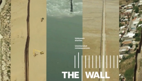
"The Wall" Border Mapping
Part of the “The Wall,” winner of the 2018 Pulitzer Prize for Explanatory Reporting, the work that GRS did with the Gannett/USA Today network included the creation of the most complete and updated map of the US-Mexico border, covering over 2000 miles.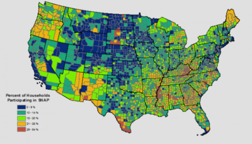
Census Data for Research
GRS is often asked to obtain census data for researchers and to perform various analyses, such as mapping demographics and processing raw tabular data into visualizations.
Data Collection and Creation
Field collection of data, processing, and creation of new data for research and client needs.
Geocoding: Mapping Addresses
Geocoding turns address data into points on a map, and can include overlay those points with some sort of area (census tract, congressional district), or creation of a map or a table showing the results.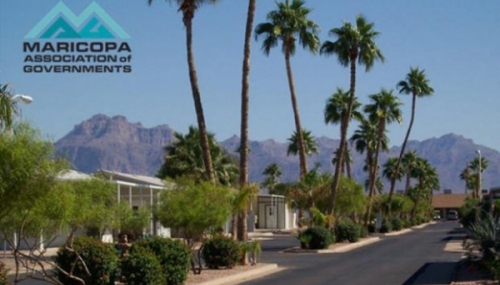
MAG Seasonal Housing Data Update
A major update to the GIS dataset pertaining to seasonal housing for the Maricopa Association of Governments (MAG).